
Topic: Selected Properties Of Earth Atmosphere
Selected Properties Of Earth Atmosphere
In which atmospheric temperature zone does most precipitation occur?
(1) thermosphere
(2) mesosphere
(3) stratosphere
(4) troposphere
Which changes in air temperature and atmospheric pressure will normally be recorded by a weather balloon when it is released at Earth’s surface and rises through the troposphere?
(1) a decrease in both air temperature and atmospheric pressure
(2) a decrease in air temperature and an increase in atmospheric pressure
(3) an increase in both air temperature and atmospheric pressure
(4) an increase in air temperature and a decrease in atmospheric pressure

Capillarity will cause water to rise highest in column
(1) A
(2) B
(3) C
(4) D
Most of Earth’s weather events take place in the
(1) thermosphere
(2) mesosphere
(3) stratosphere
(4) troposphere
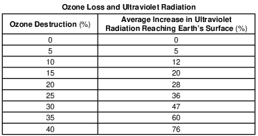
The ozone layer protects life on Earth by absorbing harmful ultraviolet radiation. The ozone layer is located between 17 kilometers and35 kilometers above Earth’s surface in which
atmospheric temperature zone?
(1) troposphere
(2) stratosphere
(3) mesosphere
(4) thermosphere
Most of the hurricanes that affect the east coast of the United States originally form over the
(1) warm waters of the Atlantic Ocean in summer
(2) warm land of the southeastern United States in summer
(3) cool waters of the Atlantic Ocean in spring
(4) cool land of the southeastern United States in spring
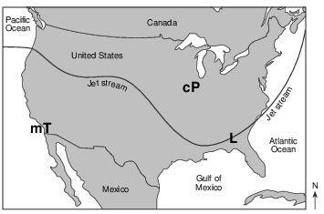
In which layer of the atmosphere is this jet stream located?
(1) thermosphere
(2) mesosphere
(3) stratosphere
(4) troposphere
As altitude increases in the troposphere and stratosphere, the air temperature
(1) decreases in the troposphere and increases in the stratosphere
(2) decreases in both the troposphere and stratosphere
(3) increases in the troposphere and decreases in the stratosphere
(4) increases in both the troposphere and stratosphere
Comets and Asteroids
Since comets and asteroids orbit the Sun, both are part of our solar system. Asteroids are rocky objects that vary greatly in size. Most asteroids follow orbits between 300 and600 million kilometers from the Sun, but several have been pulled from this region by
the gravitational attraction of nearby planets. Many of these dislodged asteroids have struck both Earth and the Moon, causing the large impact craters that are visible on the surfaces of both bodies.
Comets have often been described as “dirty snowballs” and occupy highly eccentric orbits, traveling from near the Sun to far beyond the orbits of the outer planets. As they move through space, comets leave a debris trail of mostly dust-sized particles. When Earth passes through this debris, a meteor shower occurs, often filling the night sky with “shooting star” trails as they burn up in the atmosphere 50 to 80 kilometers above Earth’s surface.
In which temperature zone of Earth’s atmosphere will most meteors burn up?
(1) troposphere
(2) stratosphere
(3) mesosphere
(4) thermosphere
At what approximate altitude in the atmosphere can stratospheric ozone be found?
(1) 10 km
(2) 30 km
(3) 70 km
(4) 100 km
The ozone layer is mostly concentrated between 20 and 25 kilometers above Earth’s surface. State the name of the atmospheric temperature zone layer where this ozone concentration can be found. [1]
Allow 1 credit for stratosphere.
Iceland Volcano Eruption Spreads Ash Cloud over Europe On April 14, 2010, Eyjafjallajökull volcano, located in southern Iceland, explosively erupted, sending large volumes of volcanic ash high into the atmosphere. Much of the ash fell quickly to Earth, as seen in the map, but large quantities remained airborne and spread over Europe. Most of the ash was transported within the atmosphere below10 kilometers. Air traffic across the Atlantic and throughout Europe was severely
disrupted, as airlines were forced to keep jet aircraft on the ground.
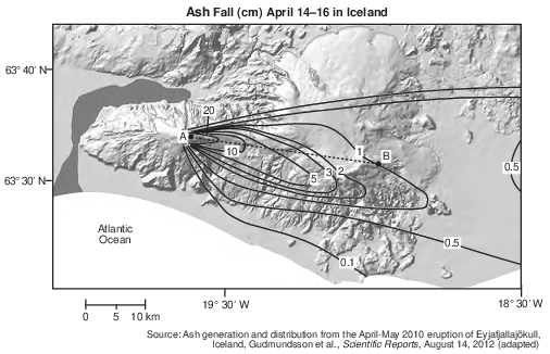
Identify the atmospheric layer within which most of the volcanic ash was transported. [1]
Allow 1 credit for troposphere.
CFCs and Ozone
CFCs (chlorofluorocarbons) are chemicals that threaten to destroy stratospheric ozone. CFCs were first manufactured in 1928 to be used as chilling agents in refrigerators. In later years, they were used for cleaning electrical circuit boards and to make foam for insulation. Unfortunately, scientists found that these chemicals escaped into the atmosphere and rose to the stratosphere. In the stratosphere, intense ultraviolet (UV) radiation broke the CFCs down, producing chlorine, a gas that reacts with and destroys ozone. In 1974, two scientists identified the depletion of stratospheric ozone from the release of CFCs. After this discovery, 27 countries agreed to reduce production of CFCs, because ozone in the stratosphere protects all life from the Sun’s most damaging UV rays.
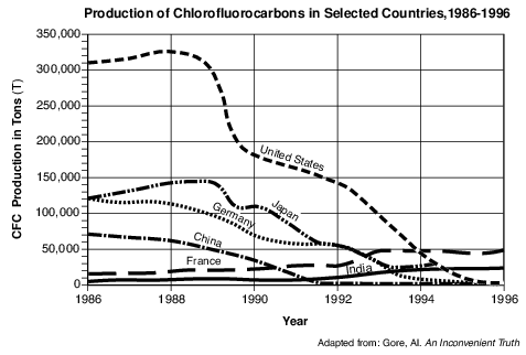
Identify the name of the atmospheric temperature zones directly below and directly above the atmospheric layer in which intense UV radiation breaks down CFCs. [1]
________________________________ and _________________________________
Allow 1 credit for troposphere and mesosphere.
The Dust Bowl
In the 1930s, several years of drought affected over 100 million acres in the Great Plains from North Dakota to Texas. For several decades before this drought, farmers had plowed the prairie and loosened the soil. When the soil became extremely dry from lack of rain, strong prairie winds easily removed huge amounts of soil from the farms, forming dust storms. This region was called the Dust Bowl.
In the spring of 1934, a windstorm lasting a day and a half created a dust cloud nearly 2000 kilometers long and caused “muddy rains” in New York State and “black snow” in Vermont. Months later, a Colorado storm carried dust approximately3 kilometers up into the atmosphere and transported it 3000 kilometers, creating
twilight conditions at midday in New York State.
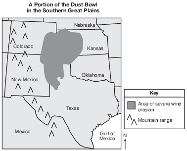
Identify the name of the layer of the atmosphere in which the dust particles were transported by the Colorado storm to New York State. [1]
Allow 1 credit for troposphere.

Describe one piece of evidence from the diagram that supports the inference that the observer is located at the Tropic of Cancer. [1]
Allow 1 credit. Acceptable responses include, but are not limited to:
• — The altitude of Polaris is at 23.5° or 23 1–2 °.
• — The noon Sun for June 21 is directly overhead.
• — The highest Sun position is at 90° (zenith) on June 21.
• — the angle/altitude of Polaris
• Note: Do not allow credit for 23 1–2 ° N or 23.5° North, because a compass direction should not be
• included with an altitude value.